Licence-Free Boat Route: East Coast (Koutsoupia & Skala)
Licence-Free Boat Route from Katelios: Heading north to the eastern shores of Kefalonia
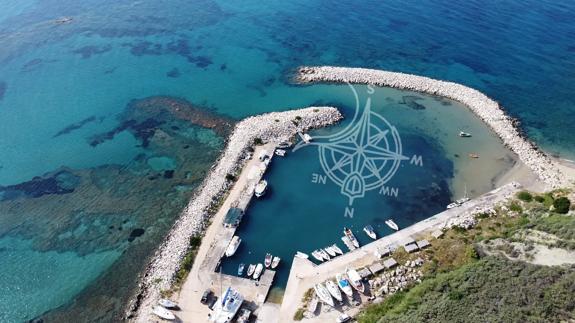
Renting a boat without a licence in Kefalonia from Katelios?
The East Route is for those who want to escape civilization. As you head North towards Poros and Koutsoupia, the hotels and roads disappear, replaced by steep green mountains that drop straight into the sea. This is the “tropical side” of Kefalonia.
Why choose this route? If you want total seclusion and snorkeling, this is the one. The coastline here is rugged and dramatic, featuring the famous “Mini Myrtos” (Koutsoupia Beach) and the hidden V-cove of Kako Lagadi. It is the smarter choice on days when the wind is blowing from the West (Ponente) or South-West (Garbis), as the mountains shield you perfectly.
This route is all about comfort and conditions. Compared to our West/South route, the East/North side is usually the smarter choice on W winds (Pounentes/Ponente), SW winds (Garbis), or S winds (Ostro/Ostria). If the NW wind (Maistros) is strong, this side can feel less forgiving—so that’s when we usually point guests to the West route.
Distances from Katelios Harbour
Renting a boat without a licence in Kefalonia from Katelios? This is the east coastal route: short, easy hops, clear water swim stops, and a simple plan you can follow without overthinking. You’ll build up from nearby beaches (Kaminia, Spithi, Skala) to longer full-day options like Xilomata and Koutsoupia.
Planning numbers for scheduling your day. Times assume a steady 15kn cruising speed (1 nm ≈ 4 minutes). Always confirm the allowed operating area and day conditions during your briefing.
- Spithi Beach ~ 2.5 nm ~10 min from Katelios
- Skala Beach — 3.4 nm ~14 min from Katelios
- Pelagos Bay — 4.3 nm ~ 17 min from Katelios
- Kako Lagadi Beach — 7.0 nm ~ 28 min from Katelios
- Cronidis Beach — 7.6 nm ~ 30 min from Katelios
- Limenia Beach — 7.8 nm ~ 31 min from Katelios
- Makria Petra — 11.0 nm ~ 44 min from Katelios
- Lazarus Beach — 12.4 nm ~ 50 min from Katelios
- Xilomata Beach — 12.7 nm ~ 51 min from Katelios
- Koutsoupia Beach — 14.6 nm ~ 58 min from Katelios
Quick Planning Checklist:
- Choose the right side for the wind: strong NW (Maistros) = usually better West route; W/SW/S (Pounentes/Garbis/Ostria) = this route is usually calmer.
- Best start: go early (calmer water, easier anchoring, fewer crowds).
- Ideal pace: 3–5 stops for a relaxed day; 6–8 stops if you move efficiently.
- Bring: water, hats, sunscreen, snorkel masks, waterproof phone pouch, and water shoes (mixed entries are common).
- Anchoring basics: choose sand patches where possible, keep distance from swimmers, and avoid anchoring on seagrass.
- Safety rule: if wind/chop increases, turn back early — don’t “push one more stop”.
⚠️ NAVIGATION DANGER ZONE: Kaminia & Mounda Cape
- Do NOT attempt to approach Kaminia or Mounda beaches. This area is extremely shallow and hazardous, featuring sharp rocky reefs and submerged ancient shipwrecks.
- Strict Navigation Rule: You must keep a safe distance and stay OUTSIDE the specific marker buoys placed by our team. Passing inside these buoys guarantees damage to the propeller and engine.
- Why skip them? These beaches are sandy and easily accessible by car or foot. Do not risk the boat here.
- Your First Stop: Cruise safely past the cape and head directly to Spithi Beach or Skala for your first swim.
1) Spithi Beach ~ 2.5 nm (The secluded cove) 38°03'54.4"N 20°47'45.3"E
Just before you round the cape towards Skala, Spithi offers a sharper, wilder contrast to Kaminia’s soft sands. It is a smaller, pebbly cove often favored by naturists due to its seclusion. The water clarity jumps up a notch here as the seabed changes from sand to rock.


2) Skala Beach ~ 3.4 nm (The resort hub) 38°04'26.2"N 20°48'03.7"E
You can’t miss it—the endless strip of parasols and blue water. Skala is the cosmopolitan hub of the south. As a boat renter, you don’t stop here for seclusion; you stop here to show off the boat or pick up supplies if really needed. The water is deep and incredibly blue, but the seabed drops off quickly.
3) Pelagos Bay ~ 4.3 nm (The rocky scenery)
38°05'28.9"N 20°48'13.9"E
Known locally by the hotel above it, this is the rocky “relief” after the bustle of Skala. It isn’t a single beach but a series of rocky coves and swim platforms carved by nature. The water here is often clearer than Skala because there is no sand to kick up. It’s a favorite spot for our skippers to take a quick snorkel break.


4) Kako Lagadi ~ 7.0 nm (The star attraction)38°07'35.6"N 20°48'04.1"E
Also known as Kato Lagadi. This is the “star” of the southern leg. A tiny, perfect V-shape cove cut into high white cliffs, with a cave hidden at the back. It is almost invisible from a distance until you are right in front of it. The water colors here—electric blue against white stone—are some of the best on the island.
5) Cronidis Beach ~ 7.6 nm (The quiet overflow) 38°07'52.0"N 20°47'35.0"E
Located just before the rocks of Limenia, Cronidis is often overlooked by boats rushing to Poros. It is a quiet, medium-sized pebble beach backed by greenery. Because it has road access, you might see a few cars, but from the water, it offers a peaceful, protected hold. It’s an excellent “Plan B” if Kako Lagadi is too crowded.


6) Limenia Beach ~ 7.8 nm (The mushroom rocks) 38°08'02.1"N 20°47'28.0"E
Easily recognized by the distinctive “mushroom” rocks rising out of the water. Limenia is not one single beach but a playground of rocky coves and pebble strips. It is a fantastic spot to drop anchor for a snorkeling break, as the rock formations create an underwater maze teeming with fish.
7) Makria Petra ~ 11.0 nm (The first cliff beach)38°10'44.4"N 20°45'19.5"E
As you head north from Poros towards Koutsoupia, you will encounter this striking, rugged coastline. True to its name (“Long Stone”), this is a long, narrow strip of white pebbles tucked beneath steep, imposing cliffs. It lacks the lush, embracing greenery of Koutsoupia, offering instead a wilder, more dramatic landscape. It is often less crowded than its northern neighbors, making it a great spot to cut the engine and drift in the deep blue water if you prefer isolation over “tropical” vibes.


8) Lazarus Beach ~12.4 nm (The sheltered bay)38°11'55.4"N 20°44'13.6"E
Located just north of Poros port, this is your first “safe haven” on the northern leg of the route. It’s a small, sheltered pebbly bay that feels like a private swimming pool. Because it is so close to Poros, it is the perfect place to stop if you see the weather turning or if you want a quick dip without committing to the longer journey north. The water here is often calmer than the open sea, making it a reliable stop for a relaxing lunch break on the boat.
9) Xilomata Beach ~ 12.7 nm (The secluded gem)38°12'12.0"N 20°43'58.8"E
Tucked between the civilized Lazarou and the wilder Makria Petra, Xilomata is a “hidden gem” often overlooked by boats rushing straight to Koutsoupia. It features a rugged, natural beauty with medium-sized pebbles and crystal-clear water. It lacks the imposing cliffs of Makria Petra but offers a high level of seclusion. It is an excellent alternative if you find Koutsoupia too crowded with other rental boats—you can often have this bay entirely to yourself.


10) Koutsoupia Beach ~ 14.6 nm (The tropical finale)38°13'36.9"N 20°42'37.0"E
This is the “clean milestone” of the route—often called “Mini Myrtos” due to its striking turquoise waters and lush green backdrop. For many guests, reaching this far north from Katelios on a licence-free boat feels like a real mini-expedition. It is the furthest safe point for a day rental. Enjoy the isolation, but don’t gamble your return: arrive early (before noon), swim properly, and head back south while conditions are still friendly to ensure a pleasant return.
FAQ about the eastern route for licence free boat rentals
Yes. All our boats are supplied with a full main tank, which is sufficient for the return trip to Koutsoupia if you drive responsibly
-
Skala (Stop 4): Fully organised with many restaurants and bars, but you must anchor well offshore.
-
Koutsoupia (Stop 12): There is often a small seasonal canteen/hut, but it is not guaranteed to be open or stocked.
-
The Recommendation: Treat this as a “wild” picnic route. Bring plenty of water and food with you so you aren’t forced to stop at a busy beach just to buy lunch.
No. You should strictly avoid entering Poros Port unless it is an emergency.
How to pass: Keep a safe distance (approx. 200m–300m) off the port entrance to avoid the ferries. You will clearly see the breakwater. Just cruise past it towards the long beach of Ragia.
Kako Lagadi is beautiful but very narrow. If there are already 2–3 boats inside the “V” shape, do not try to squeeze in.
-
The Solution: Drop anchor further out in deeper water and swim in, or simply take your photos and move 5 minutes north to Cronidis Beach, which is usually empty and easier to anchor.
Ready to schedule your boat day?